
Enhancing Safety on Franklin Street

Enhancing Safety on Franklin Street
By Mark Dreger

We're excited to share an update on the Franklin Street Quick-Build Project, an effort to enhance traffic safety on Franklin Street between Broadway and Lombard Streets. This roadway stretch was the site of 38 collisions between 2017 and 2021, including the tragic loss of a Sherman Elementary School paraeducator in November 2021. Our data-driven approach focuses on several key safety improvements, and we are ready to share the evaluation results and the next steps to bring further safety changes to Franklin Street. 

The project includes the implementation of a suite of safety measures focused on the intersections where neighborhood stakeholders expressed most concerns during the outreach process. 

  • Painted safety zones (PSZs) have been installed to increase pedestrian visibility at crosswalks by keeping the corners of intersections clear.

  • Slow-turn wedges have been added to encourage drivers to turn at safer speeds and at angles that make people crossing more visible. 

  • Daylighting, or removing parking spaces next to intersections, was used to keep areas near crossings clear. This ensures that parked cars don’t prevent drivers and pedestrians from seeing each other. 

  • Right-turn-on-red restrictions have been applied to keep crosswalks clear and minimize conflicts between people driving and walking. 


A city crosswalk with enhanced safety designs.
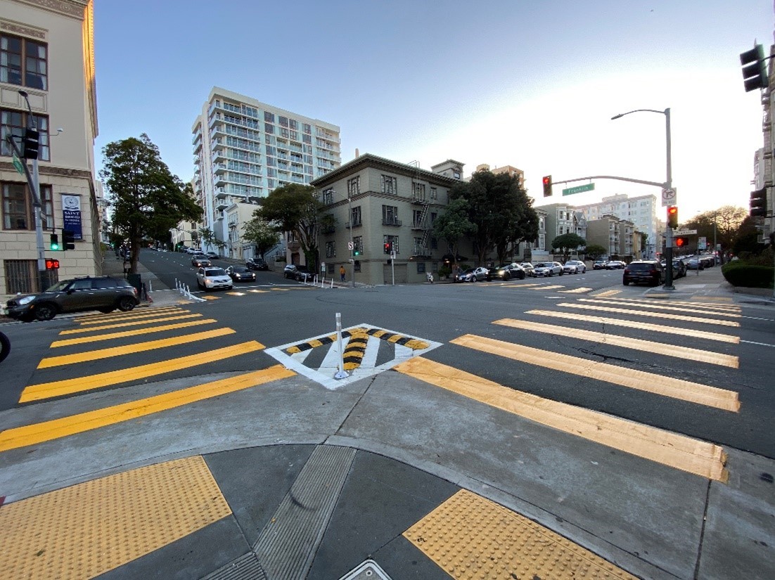
A slow-turn wedge at the intersection of Franklin and Broadway implemented as part of the Franklin Street Quick-Build Project.

The initial results offer some signs of progress: 

  • Reduced close calls: After implementation, there were no recorded 'close calls' between people driving and people walking in crosswalks, compared to three such incidents before. 

  • Right-turn compliance: Drivers complied with the new right-turn restrictions 94% of the time, indicating that drivers are adhering to the new rules. 

However, there are areas where the project did not yield significant changes: 

  • Driver yielding rates: Drivers yielded to pedestrians 60% of the time after these changes were implemented, as opposed to 61% before.  

  • Vehicle speeds: Both turning and mid-block speeds remained largely unaffected by the changes. Turning speeds are holding at approximately 10-11 mph, which is below the 15-mph safety threshold set by the National Association of City Transportation Officials (NACTO), and mid-block speeds remain slightly above the 25-mph speed limit. 

What's Next 

While the project did improve intersection safety, it was not effective at reducing speeds along Franklin Street. The corridor is on the Vision Zero High-Injury Network – the 12% of streets that account for 68% of severe and fatal traffic collisions. So, in line with our commitment to Vision Zero, we’re taking the following steps to further increase safety on Franklin Street. 

  1. Road diet: We plan to reduce Franklin from three lanes to two between Broadway and Lombard Street. This lane reduction should reduce mid-block speeds. People driving more slowly are more likely to see people crossing the street and have time to yield to them. 

  1. Enhanced intersection designs between Market Street and Broadway: The remainder of Franklin Street from Market Street to Broadway will see enhanced intersection designs using the Quick-Build Toolkit — including painted safety zones, slow-turn wedges and daylighting — creating a uniformly safer walking experience along the corridor. 

  1. Long-term projects: Our team is brainstorming how to incorporate more significant changes with future projects on and around Franklin Street.

Improving traffic safety is an evolving process and we're committed to making Franklin Street safe and accessible for everyone. While the project has made some headway, it's clear that more work is needed. We appreciate the community's ongoing involvement and look forward to your continued support as we embark on the next steps. 

For more information on the Franklin Street Quick-Build Project, please visit our project website (SFMTA.com/FranklinQB) or contact our project team by email at FranklinQB@sfmta.com.


Published September 13, 2023 at 10:37PM
https://ift.tt/9MJZypV

Comments

Popular posts from this blog

New Customer Information System Signs Coming to a Transit Shelter Near You!

New Customer Information System Signs Coming to a Transit Shelter Near You! By Kharima Mohamed As part of the Next Generation Customer Information System project, over 700 new Liquid Crystal Display (LCD) signs will display real-time information at Muni transit shelters. Approximately one-third of these signs will be double-sided to provide additional visibility at the highest-ridership stops and major transfer points. This week we installed a single-sided prototype at Eddy and Larkin streets. Serving the Tenderloin, an Equity Neighborhood , this sign will feature real-time predictions for the 19 Polk and 31 Balboa routes. The primary purpose for installing this prototype is to conduct in-field hardware testing, especially with rain, wind and colder temperatures.    We know there is an urgent need for more effective signage and are excited to roll out the new customer information system later this year.  The new LCD signs will eventually replace all existing Next...

What a Year It Has Been! Let the Celebration of Transit Month Continue

What a Year It Has Been! Let the Celebration of Transit Month Continue By Erin McMillan 49 Van Ness/Mission using the brand new bus rapid transit lanes on opening day in April. During Transit Month this September, we’re continuing the celebration by looking back to more of the work we’ve done over the last year— some that has been less obvious to Muni customers, but critical to a well-functioning system and other work that is more front and center. Fix It! Week and Continuing State of good Repair Work Muni is an impressive transit system. Moving thousands of people on rail and buses every day takes a lot of coordination and a lot of work. Dealing with unique challenges like San Francisco’s geography and shifting travel patterns, we also have to deal with issues related to the Muni system’s age. Proper care and maintenance of a transit system many decades old takes strategic planning as regular maintenance needs to happen while continuing to provide service. Typically, regular Mun...

Street Transformations to Address COVID-19 Keep San Francisco Moving

Street Transformations to Address COVID-19 Keep San Francisco Moving By Eillie Anzilotti A street closure in the Tenderloin as part of the COVID-19 response efforts. Since the start of the COVID-19 pandemic in March 2020, many aspects of people’s lives have changed – including how we get around town. To reflect this new reality, the SFMTA pivoted in the way we design and operate our streets. From streets that prioritized people walking and bicycling in some of San Francisco’s major parks to Temporary Transit Lanes (TETLs) that protected Muni lines from the return of traffic congestion, San Francisco reimagined how streets could be used for people. We have documented some of these transformations in a new report that highlights emergency street operations, Temporary Emergency Transit Lanes , the Slow Streets Program , Tenderloin street closures and reusing streets within or close to parks for recreational purposes. Within each effort, the report touches on the ways in which city ...

Agra: All historical monuments except Taj Mahal to reopen from September 1 https://ift.tt/2YnrJQd

The Agra district administration on Thursday announced that all historical monuments here, other than the Taj Mahal and the Agra Fort, will reopen from September 1. District Magistrate P.N. Singh said that the monuments -- Fatehpur Sikri, Sikandara, Etmauddaulabs tom, Ram Bagh, Mehtab Bagh and a few other smaller ones would be thrown open to public, but with a set of conditions.

New Dashboards Give a Window into Muni Service Changes

New Dashboards Give a Window into Muni Service Changes By Kate McCarthy An inspector manages Muni service. New dashboards that help inform changes to Muni service are now live at SFMTA.com/MuniData Many factors inform our decisions about Muni service adjustments. These include making sure changes to service support the SFMTA’s values, which are economic vitality, environmental stewardship, trust and equity. We also evaluate travel patterns. You can now explore these patterns using the new Muni data dashboards  (SFMTA.com/MuniData). When looking at possible Muni service changes, the first thing we do is turn to the Muni Service Equity Strategy for guidance. Using the Muni Service Equity Strategy, we prioritize providing Muni service along routes that more often serve people of color, members of low-income households, and/or those who are dependent upon transit service, including people with disabilities and seniors. We also use ridership data to analyze where riders are boa...

Powered Scooters Charge City’s Transportation Recovery

Powered Scooters Charge City’s Transportation Recovery By Jason Hyde The SFMTA is releasing its next round of Powered Scooter Share permits on July 1. Scooters remain a sustainable mode of travel and a complement to Muni and public transit service as the city recovers from the pandemic and San Franciscans begin to travel more. The SFMTA’s Powered Scooter Share Program is essential in ensuring that shared scooter operations support the city’s economic recovery in a safe, sustainable, and equitable way.  The SFMTA received four submittals for the permit program and will issue permits to two operators : Spin and Lime. Permits will be in effect for a one-year term, with the option to extend for another year at the discretion of the SFMTA based on compliance with various program metrics. While the new permit program does not set a limit on the number of scooters each operator may deploy, it does limit the overall citywide fleet size at 10,000. Starting at a base of 2,000 scooters...

The Future of Slow Streets

The Future of Slow Streets By Eillie Anzilotti Over the past two years, Slow Streets have shown how simple designs that prioritize people can transform streets. Suddenly, streets across San Francisco filled with the sounds of kids playing and neighbors chatting. They filled with people on bicycles and people rolling in wheelchairs; with joggers and dog-walkers. The streets came to life. Initially, the SFMTA introduced Slow Streets as an emergency response to COVID-19. People needed space for recreating at a safe distance outdoors. And with Muni service reduced or suspended at the time, people needed ways to travel to essential destinations on foot or bike. To quickly meet these early pandemic needs, we implemented Slow Streets with simple signs and barricades. Over time, it became clear that Slow Streets served an even larger purpose. They became places for communities to come together. Neighbors organized events like scavenger hunts and Trick or Treat parties around their local Sl...

Geary Boulevard Improvement Project Update

Geary Boulevard Improvement Project Update By Amy Fowler Geary Boulevard is a critical east-west arterial and one of the busiest bus corridors in North America, connecting downtown San Francisco to the Richmond District. The SFMTA has been busy working on the second phase of planned improvements on Geary, called the Geary Boulevard Improvement Project , to improve Muni’s 38 Geary bus service and address traffic safety between 34th Avenue and Stanyan Street.  The project is building on the success of the Geary Rapid Project , which was recently completed on time and on budget and has already shown promising travel time savings on the eastern half of the Geary corridor.    Last fall, we asked neighbors in the Richmond about their priorities for transit, safety and driving issues on Geary via pop-up events on the corridor and a Virtual Open House. Thanks to input from over 600 community members , the SFMTA has used this feedback to draft the detailed, block-by-bloc...

SFMTA to Replace All Parking Meters in the City

SFMTA to Replace All Parking Meters in the City By Jessie Liang San Franciscans will see new parking meters on city streets beginning in early March 2022. Staff from the SFMTA’s Parking Meter Shop will replace the meters at all the nearly 27,000 paid parking spaces in the city because those meters have reached the end of their useful lives, and because many of the meters rely on 3G communications technology that soon will be phased out by the wireless companies. The first new meters will be installed in the South of Market and Mission Bay neighborhoods.  SFMTA staff will provide notices on vehicle windshields when the new meters are activated.  The new meters will provide several benefits, including larger and more legible screens, more intuitive user interface, more powerful batteries, and more resistance to vandalism.   The following neighborhoods will move to a pay-by-license-plate system with new paystations. South Beach SoMa Mission Bay Civic Center H...

Looking Back at the Roots of Muni Heritage Day

Looking Back at the Roots of Muni Heritage Day By Jeremy Menzies Muni Heritage Day returns this Saturday, June 4 from 10 a.m. to 4 p.m., after a two-year hiatus. This event brings our unique fleet of vintage buses and historic streetcars back on San Francisco streets for free rides. All rides will originate from Steuart Street and Don Chee Way, just outside the SF Railway Museum . In preparation for Saturday’s festivities, we look back at the origins of this event in the 1980s through some newly scanned historic photos.  Seen here at the 1983 Trolley Festival, the “Boat Tram” has always been a crowd pleaser.  The story of Muni Heritage is intertwined with both that of the F Line and a series of events called “Trolley Festivals”. The inaugural Trolley Festival in 1983 was the first time Muni ran special rail service using a collection of vintage cars from San Francisco and around the world. Today, Muni Heritage carries on this tradition for people to ride vehicles that ar...