
A Brief History of the T Third Part 2: 1980s-2023

A Brief History of the T Third Part 2: 1980s-2023
By Jeremy Menzies

Beginning in January 2023 full service on the new T Third extension 2023 will run from Sunnydale to Chinatown every day. In this two-part blog series, we will look back at some of the history of the T Third Street line. Part 1, published last month goes through the first 100+ years. In Part 2, we look at the recent history of the T Third and Central Subway projects from the 1980s to today. 

The Call for Better Transit: 1980s-90s 

In the decades following World War II, the neighborhoods along the southern end of 3rd Street became more economically depressed and transit service declined.  Residents felt cut off from the rest of the city as bus service did not meet their needs. 

Passengers lining up to board a bus on a busy city street with buildings in the background 
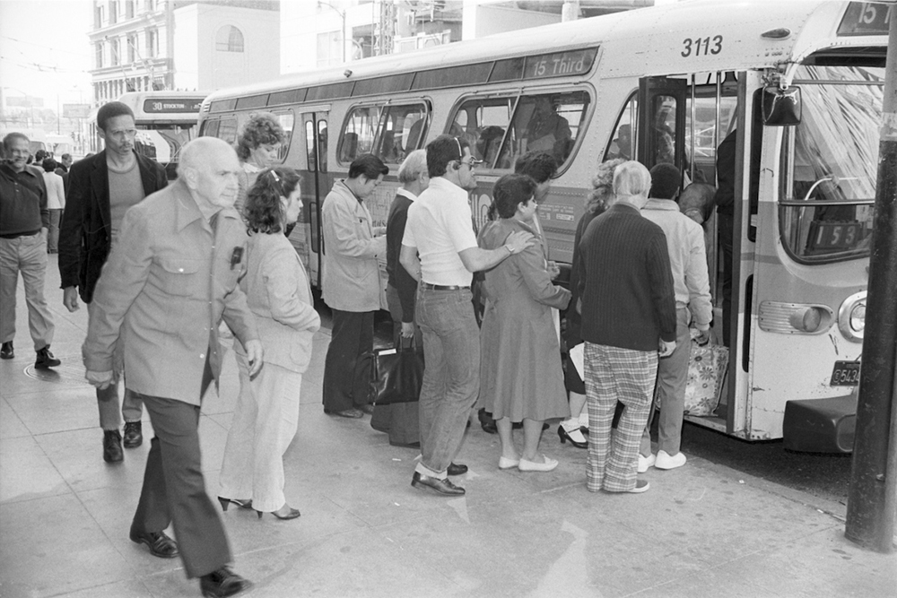
People boarding a 15 Route bus on 3rd Street near Market in 1983. Bus service on the 15 provided critical north-south service through the City’s busiest areas. 

In the late 1980s, the city was looking to revitalize the Mission Bay, Dogpatch, and Bayview and reliable transit was critical to this goal. Early outreach and research resulted in the 1993 Bayshore Transit Study. This initial plan solicited community input on several possible solutions on how to improve transit to these neighborhoods. Two years later in 1995, the Four Corridor Plan built upon the Bayshore Transit Study and elevated 3rd street as the top priority for San Francisco’s long-range transit plan. It was clear that residents, particularly in Bayview, wanted rail service to return to 3rd Street. 

T Third Phase 1: 1990s-2007 

These reports and outreach formed the backbone of the Third Street Light Rail Project, which would be built in two initial Phases. Phase 1 involved extending Muni Metro service from 4th and King to Bayshore Boulevard along 3rd Street. Phase 2 would focus on the 4th and Stockton corridors to extend the service into Chinatown and possibly North Beach. 

By the end of the ‘90s, funding was coming in to make Phase 1 a reality. Early plans for the T also included a new rail maintenance facility, Muni Metro East, as well as a turnback loop in Mission Bay and a direct connection to the Bayshore Caltrain Station. Due to various factors during preconstruction planning, the Mission Bay Loop and Bayshore Caltrain connection were dropped from the T Line plan. 

People in business attire and hard hats smiling with shovels in hand over a large pile of dirt under s station structure

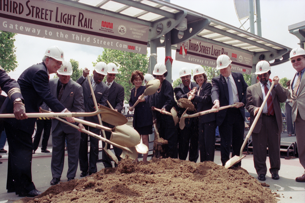
A groundbreaking ceremony for T Third construction was held on May 28, 2002 at the 4th and King Caltrain Station.  

Construction of 5.1 miles of new tracks, overhead power lines, lighting, stations, and a variety of other improvements took five years to complete. On January 13, 2007, free weekend shuttle service commenced on the new line and full weekday service started on April 7. Just one year later in 2008, the Muni Metro East rail yard opened, boosting Muni’s ability to serve the new line. For the first time in 50 years, rail service returned to the eastern waterfront. 

A long perspective view of a corridor showing the city's neighborhood skyline 
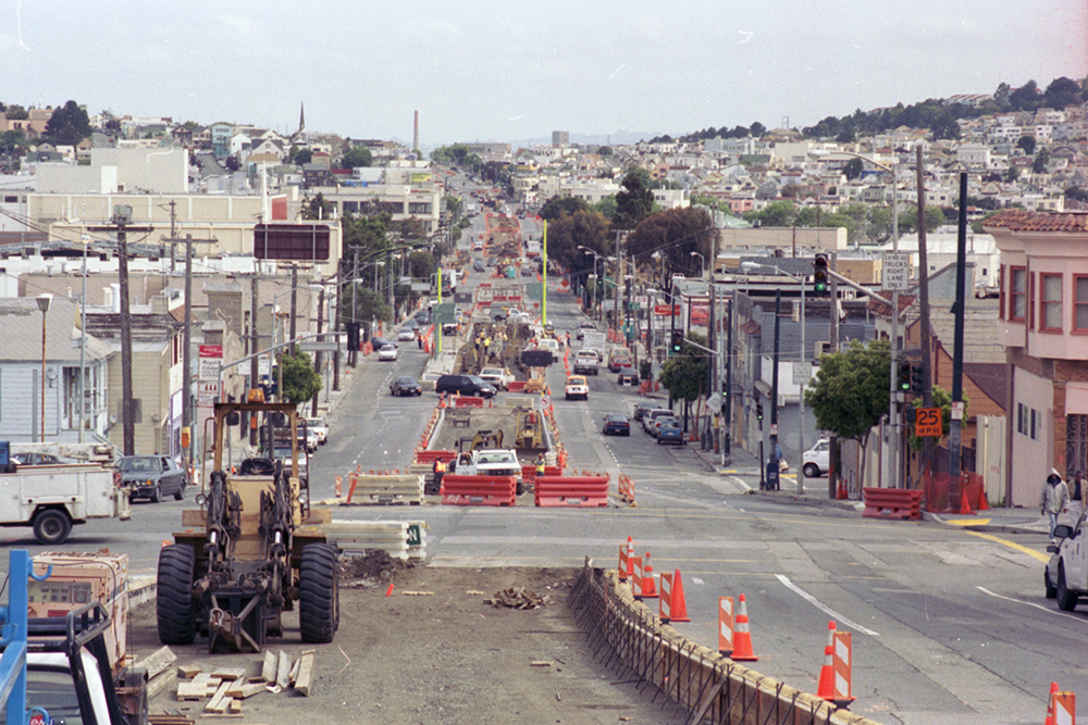
View north along 3rd Street at Jamestown Avenue during construction in 2004. 

T Third Phase 2: Central Subway 

Planning and outreach for Phase 2 of the T Line had already begun when the line opened in 2007. The Central Subway Project was created to address the transit needs of Chinatown, Union Square and South of Market. Construction would extend the T nearly two miles and build the first new subway in the city since the 1970s.

Construction and crew underground in a front of two boring entrances 
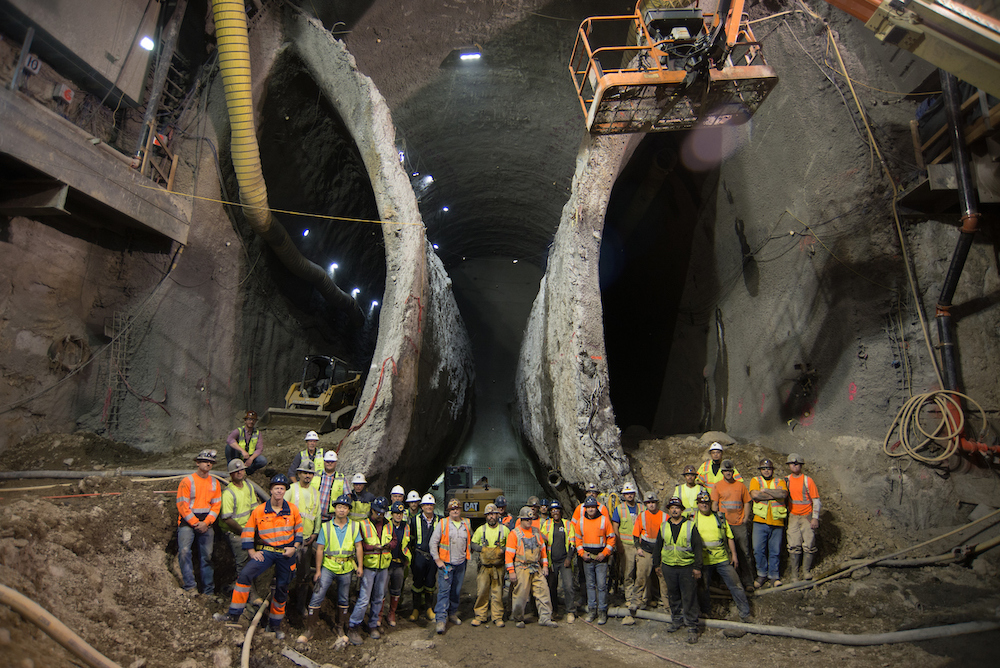
This 2016 photo, taken inside the excavation for Chinatown Station shows the massive scale of the Central Subway Project. 

Early proposals showed the Central Subway traveling north on 3rd Street and along Geary where it would turn up Stockton to end in Chinatown. Going south, the line would branch and exit the tunnel on 4th Street. The challenges of construction along 3rd and at Market Street resulted in a plan to run the line on 4th and Stockton streets. It was also decided to tunnel underneath the Market Street Subway/BART tunnels using special tunnel boring machines instead of more conventional construction methods. 

The official groundbreaking ceremony took place on February 9, 2010. The arduous process of building a subway with four stations through San Francisco’s densest neighborhoods began soon after. Despite an intensive construction period with project delays and cost increases, the Central Subway opened for service on November 19, 2022.  

Passengers boarding onto a train in a station on a busy platform
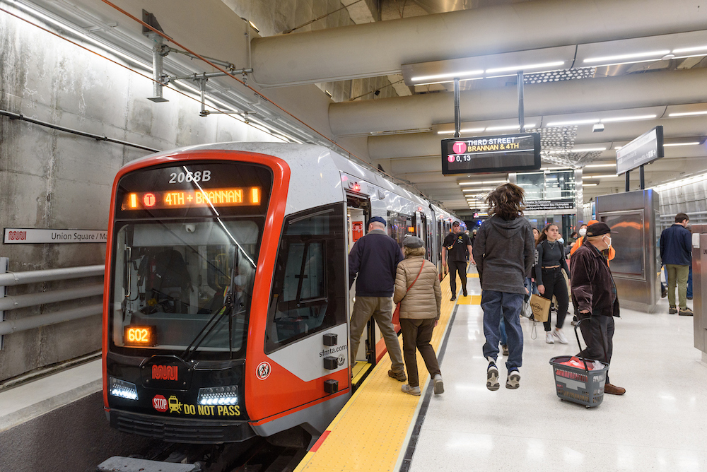
Opening day of the Central Subway on November 19, 2022. Thousands of people came out to see and ride in the long-awaited subway. 

Over 30 years in the making, the T Third line follows in the footsteps of the first horsecars that ran over 160 years ago. However, this is not the end of the line for the T. Planning is already underway on the T Third Phase 3 extension. Aimed at expanding service beyond 3rd Street, this extension will mark yet another chapter in San Francisco’s transportation history. 


Published December 16, 2022 at 12:52AM
https://ift.tt/GZa3Eg2

Comments

Popular posts from this blog

New Customer Information System Signs Coming to a Transit Shelter Near You!

New Customer Information System Signs Coming to a Transit Shelter Near You! By Kharima Mohamed As part of the Next Generation Customer Information System project, over 700 new Liquid Crystal Display (LCD) signs will display real-time information at Muni transit shelters. Approximately one-third of these signs will be double-sided to provide additional visibility at the highest-ridership stops and major transfer points. This week we installed a single-sided prototype at Eddy and Larkin streets. Serving the Tenderloin, an Equity Neighborhood , this sign will feature real-time predictions for the 19 Polk and 31 Balboa routes. The primary purpose for installing this prototype is to conduct in-field hardware testing, especially with rain, wind and colder temperatures.    We know there is an urgent need for more effective signage and are excited to roll out the new customer information system later this year.  The new LCD signs will eventually replace all existing Next...

What a Year It Has Been! Let the Celebration of Transit Month Continue

What a Year It Has Been! Let the Celebration of Transit Month Continue By Erin McMillan 49 Van Ness/Mission using the brand new bus rapid transit lanes on opening day in April. During Transit Month this September, we’re continuing the celebration by looking back to more of the work we’ve done over the last year— some that has been less obvious to Muni customers, but critical to a well-functioning system and other work that is more front and center. Fix It! Week and Continuing State of good Repair Work Muni is an impressive transit system. Moving thousands of people on rail and buses every day takes a lot of coordination and a lot of work. Dealing with unique challenges like San Francisco’s geography and shifting travel patterns, we also have to deal with issues related to the Muni system’s age. Proper care and maintenance of a transit system many decades old takes strategic planning as regular maintenance needs to happen while continuing to provide service. Typically, regular Mun...

Street Transformations to Address COVID-19 Keep San Francisco Moving

Street Transformations to Address COVID-19 Keep San Francisco Moving By Eillie Anzilotti A street closure in the Tenderloin as part of the COVID-19 response efforts. Since the start of the COVID-19 pandemic in March 2020, many aspects of people’s lives have changed – including how we get around town. To reflect this new reality, the SFMTA pivoted in the way we design and operate our streets. From streets that prioritized people walking and bicycling in some of San Francisco’s major parks to Temporary Transit Lanes (TETLs) that protected Muni lines from the return of traffic congestion, San Francisco reimagined how streets could be used for people. We have documented some of these transformations in a new report that highlights emergency street operations, Temporary Emergency Transit Lanes , the Slow Streets Program , Tenderloin street closures and reusing streets within or close to parks for recreational purposes. Within each effort, the report touches on the ways in which city ...

Agra: All historical monuments except Taj Mahal to reopen from September 1 https://ift.tt/2YnrJQd

The Agra district administration on Thursday announced that all historical monuments here, other than the Taj Mahal and the Agra Fort, will reopen from September 1. District Magistrate P.N. Singh said that the monuments -- Fatehpur Sikri, Sikandara, Etmauddaulabs tom, Ram Bagh, Mehtab Bagh and a few other smaller ones would be thrown open to public, but with a set of conditions.

New Dashboards Give a Window into Muni Service Changes

New Dashboards Give a Window into Muni Service Changes By Kate McCarthy An inspector manages Muni service. New dashboards that help inform changes to Muni service are now live at SFMTA.com/MuniData Many factors inform our decisions about Muni service adjustments. These include making sure changes to service support the SFMTA’s values, which are economic vitality, environmental stewardship, trust and equity. We also evaluate travel patterns. You can now explore these patterns using the new Muni data dashboards  (SFMTA.com/MuniData). When looking at possible Muni service changes, the first thing we do is turn to the Muni Service Equity Strategy for guidance. Using the Muni Service Equity Strategy, we prioritize providing Muni service along routes that more often serve people of color, members of low-income households, and/or those who are dependent upon transit service, including people with disabilities and seniors. We also use ridership data to analyze where riders are boa...

Powered Scooters Charge City’s Transportation Recovery

Powered Scooters Charge City’s Transportation Recovery By Jason Hyde The SFMTA is releasing its next round of Powered Scooter Share permits on July 1. Scooters remain a sustainable mode of travel and a complement to Muni and public transit service as the city recovers from the pandemic and San Franciscans begin to travel more. The SFMTA’s Powered Scooter Share Program is essential in ensuring that shared scooter operations support the city’s economic recovery in a safe, sustainable, and equitable way.  The SFMTA received four submittals for the permit program and will issue permits to two operators : Spin and Lime. Permits will be in effect for a one-year term, with the option to extend for another year at the discretion of the SFMTA based on compliance with various program metrics. While the new permit program does not set a limit on the number of scooters each operator may deploy, it does limit the overall citywide fleet size at 10,000. Starting at a base of 2,000 scooters...

The Future of Slow Streets

The Future of Slow Streets By Eillie Anzilotti Over the past two years, Slow Streets have shown how simple designs that prioritize people can transform streets. Suddenly, streets across San Francisco filled with the sounds of kids playing and neighbors chatting. They filled with people on bicycles and people rolling in wheelchairs; with joggers and dog-walkers. The streets came to life. Initially, the SFMTA introduced Slow Streets as an emergency response to COVID-19. People needed space for recreating at a safe distance outdoors. And with Muni service reduced or suspended at the time, people needed ways to travel to essential destinations on foot or bike. To quickly meet these early pandemic needs, we implemented Slow Streets with simple signs and barricades. Over time, it became clear that Slow Streets served an even larger purpose. They became places for communities to come together. Neighbors organized events like scavenger hunts and Trick or Treat parties around their local Sl...

Geary Boulevard Improvement Project Update

Geary Boulevard Improvement Project Update By Amy Fowler Geary Boulevard is a critical east-west arterial and one of the busiest bus corridors in North America, connecting downtown San Francisco to the Richmond District. The SFMTA has been busy working on the second phase of planned improvements on Geary, called the Geary Boulevard Improvement Project , to improve Muni’s 38 Geary bus service and address traffic safety between 34th Avenue and Stanyan Street.  The project is building on the success of the Geary Rapid Project , which was recently completed on time and on budget and has already shown promising travel time savings on the eastern half of the Geary corridor.    Last fall, we asked neighbors in the Richmond about their priorities for transit, safety and driving issues on Geary via pop-up events on the corridor and a Virtual Open House. Thanks to input from over 600 community members , the SFMTA has used this feedback to draft the detailed, block-by-bloc...

SFMTA to Replace All Parking Meters in the City

SFMTA to Replace All Parking Meters in the City By Jessie Liang San Franciscans will see new parking meters on city streets beginning in early March 2022. Staff from the SFMTA’s Parking Meter Shop will replace the meters at all the nearly 27,000 paid parking spaces in the city because those meters have reached the end of their useful lives, and because many of the meters rely on 3G communications technology that soon will be phased out by the wireless companies. The first new meters will be installed in the South of Market and Mission Bay neighborhoods.  SFMTA staff will provide notices on vehicle windshields when the new meters are activated.  The new meters will provide several benefits, including larger and more legible screens, more intuitive user interface, more powerful batteries, and more resistance to vandalism.   The following neighborhoods will move to a pay-by-license-plate system with new paystations. South Beach SoMa Mission Bay Civic Center H...

Looking Back at the Roots of Muni Heritage Day

Looking Back at the Roots of Muni Heritage Day By Jeremy Menzies Muni Heritage Day returns this Saturday, June 4 from 10 a.m. to 4 p.m., after a two-year hiatus. This event brings our unique fleet of vintage buses and historic streetcars back on San Francisco streets for free rides. All rides will originate from Steuart Street and Don Chee Way, just outside the SF Railway Museum . In preparation for Saturday’s festivities, we look back at the origins of this event in the 1980s through some newly scanned historic photos.  Seen here at the 1983 Trolley Festival, the “Boat Tram” has always been a crowd pleaser.  The story of Muni Heritage is intertwined with both that of the F Line and a series of events called “Trolley Festivals”. The inaugural Trolley Festival in 1983 was the first time Muni ran special rail service using a collection of vintage cars from San Francisco and around the world. Today, Muni Heritage carries on this tradition for people to ride vehicles that ar...