
How People Traveled Through San Francisco in 2021

How People Traveled Through San Francisco in 2021
By Maia Moran

Earth Day is April 22 and a great time to think about changes we can make in our own lives to support the health of our planet. When it comes to climate change, one of the most meaningful actions we can take is to drive less and get around more by biking, walking and taking forms of public transportation like Muni. Transportation is the largest source of greenhouse gas emissions (GHG) in San Francisco, with personal driving accounting for 72% of the sector’s emissions. By comparison, Muni accounts for about 1% of GHG emissions in and out of the city. 

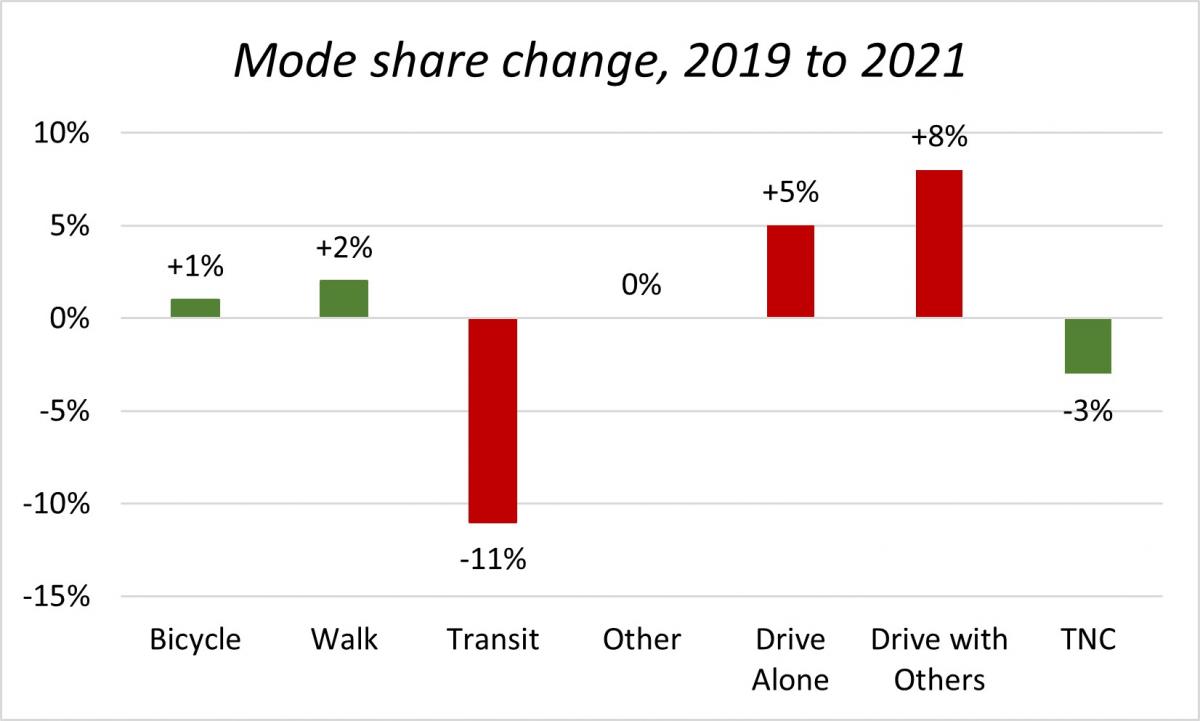
But when it comes to driving less, the San Francisco Bay Area is going in the wrong direction. Public transit use fell by 11% between 2019 and 2021 and private automobile use increased by 13%, according to the results of the 2021 Travel Decision Survey. That’s why we’ve been working so hard to make transit, walking and biking more appealing and convenient with new transit lanes, better ventilation on Muni, protected bike lanes and more. 

Travel Decision Survey 

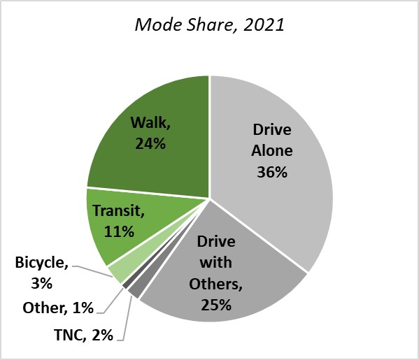
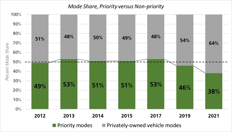
Once every two years, the SFMTA conducts a telephone survey of over 750 Bay Area residents to ask them questions about their daily travel patterns and how they get to destinations in and around San Francisco. Results from the 2021 Travel Decision Survey (TDS) indicate that the COVID-19 pandemic has driven a shift away from our vision for a transit-first city. The survey allows us to understand whether people in San Francisco are traveling by “priority” modes (walking, biking and public transit). Priority modes are those encouraged by San Francisco’s long-standing transit-first policy, which seeks to improve the city’s economy, environment and quality of life. Trips by transportation network companies (TNCs) such as Uber and Lyft, driving with others and driving alone are all categorized as “privately owned vehicle” modes and grouped into one category.  

2021 Mode Share pie chart with 7 categories, split into green and grey color shades representing the two mode-type groups. Green represents priority modes; priority mode share percentages are 24 percent walk, 11 percent transit, and 3 percent bicycle. Grey represents privately-owned vehicle modes; privately-owned vehicle mode share percentages are 36 percent drive alone, 25 percent drive with others, 2 percent Transportation Network Company, and 1 percent other.

Key Findings 

Using San Francisco County Transportation Agency data, the total number of anticipated daily trips decreased from 4.5 million in 2019 to 4.4 million in 2021, consistent with daily travel pattern shifts prompted by the pandemic such as more people working at home and fewer commuting to offices. Despite an agency goal of increasing travel by priority modes, the share for these trips fell from just under half (46%) in 2019 to just under two-fifths (38%) in 2021.  

Mode share over time bar chart grouped into priority modes and non-priority modes. Priority modes are green, non-priority modes are grey. Percent mode share in 2012 was 49 percent priority, 51 percent non-priority. Percent mode share in 2013 was 53 percent priority, 48 percent non-priority. Percent mode share in 2014 was 51 percent priority, 50 percent non-priority. Percent mode share in 2015 was 51 percent priority, 49 percent non-priority. Percent mode share in 2017 was 53 percent priority, 48 percent non-priority. Percent mode share in 2019 was 46 percent priority, 54 percent non-priority. Percent mode share in 2021 was 38 percent priority, 64 percent non-priority.

The most significant decrease in travel mode was by public transit, which fell 11% between 2019 and 2021. The most significant increase in travel mode was by private automobile use, including both driving with others (up 8%) and driving alone (up 5%). Walking and biking both had minor increases. 

Mode share change from 2019 to 2021 bar chart. Between 2019 and 2021 surveys, mode share change was 1 percent increase for bicycle, 2 percent increase for walk, 11 percent decrease for transit, 0 percent change for other, 5 percent increase for drive alone, 8 percent increase for drive with others, and 3 percent decrease for TNC.

San Francisco residents still used priority modes twice as often as non-residents for trips within San Francisco. Respondents with a household income of $75,000 or less had the highest transit ridership, while a majority of those with incomes over $75,000 chose non-priority modes. Individuals identifying as women or non-binary were more likely to travel by privately owned vehicles than those identifying as men. 

The Future of Travel 

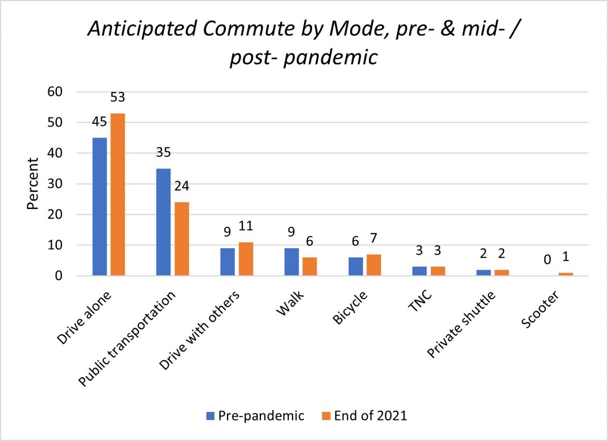
Many of the travel pattern changes revealed by the survey were likely a result of the COVID-19 pandemic, during which many people limited their non-essential travel and worked from home instead of commuting to an office.  

Anticipated commute by mode, for pre- & mid- pandemic. Pre-pandemic, 45 percent of commuters drove alone; end of 2021, 53 percent of commuters anticipated driving alone. Pre-pandemic, 35 percent of commuters used public transit; end of 2021, 24 percent of commuters anticipated using public transit. Pre-pandemic, 9 percent of commuters drove with others; end of 2021, 11 percent of commuters anticipated driving with others. Pre-pandemic, 9 percent of commuters walked; end of 2021, 6 percent of commuters anticipated walking. Pre-pandemic,6 percent of commuters biked; end of 2021, 7 percent of commuters anticipated biking. Pre-pandemic, 3 percent of commuters used a TNC; end of 2021, 3 percent of commuters anticipated using a TNC. Pre-pandemic, 2 percent of commuters used a private shuttle; end of 2021, 2 percent of commuters anticipated using a private shuttle. Pre-pandemic, 0 percent of commuters used a scooter; end of 2021, 1 percent of commuters anticipated using a scooter.

But as the city recovers from the effects of the pandemic and travel begins to increase, we urgently need to educate Bay Area residents about how their travel decisions impact our environment. To meet San Francisco’s climate goals, including net zero emissions by the year 2040, it is critical that many of us shift from driving personal vehicles to taking public transit, walking, bicycling and using other “non-carbon” travel modes. 

To encourage that shift, the SFMTA has improved the speed and reliability of our most popular bus lines by creating an unprecedented number of transit lanes. We introduced changes to make Muni more equitable. We recently increased the staff presence on Muni vehicles to deter crime and increase safety. We also upgraded our transit fleet HVAC systems, which now turn the air over once every minute. Earlier this month, we launched the Van Ness Bus Rapid Transit Corridor, and later this year the Central Subway extension to Chinatown will be open to one and all.  

To complement transit use, we have created safe bicycling and walking routes throughout San Francisco. The city now boasts 42 miles of protected bike lanes and approximately 43 miles of Slow Streets where through traffic is limited. By lowering speed limits and completing Quick Build street improvements, we’ve made walking and bicycling safer and more comfortable.  

Now, we need to make sure people in the San Francisco Bay Area know about and take advantage of these improvements. 

The 2021 Travel Decision Survey report and results are available to download here.


Published April 19, 2022 at 08:02PM
https://ift.tt/v9gLHZ8

Comments

Popular posts from this blog

New Customer Information System Signs Coming to a Transit Shelter Near You!

New Customer Information System Signs Coming to a Transit Shelter Near You! By Kharima Mohamed As part of the Next Generation Customer Information System project, over 700 new Liquid Crystal Display (LCD) signs will display real-time information at Muni transit shelters. Approximately one-third of these signs will be double-sided to provide additional visibility at the highest-ridership stops and major transfer points. This week we installed a single-sided prototype at Eddy and Larkin streets. Serving the Tenderloin, an Equity Neighborhood , this sign will feature real-time predictions for the 19 Polk and 31 Balboa routes. The primary purpose for installing this prototype is to conduct in-field hardware testing, especially with rain, wind and colder temperatures.    We know there is an urgent need for more effective signage and are excited to roll out the new customer information system later this year.  The new LCD signs will eventually replace all existing Next...

What a Year It Has Been! Let the Celebration of Transit Month Continue

What a Year It Has Been! Let the Celebration of Transit Month Continue By Erin McMillan 49 Van Ness/Mission using the brand new bus rapid transit lanes on opening day in April. During Transit Month this September, we’re continuing the celebration by looking back to more of the work we’ve done over the last year— some that has been less obvious to Muni customers, but critical to a well-functioning system and other work that is more front and center. Fix It! Week and Continuing State of good Repair Work Muni is an impressive transit system. Moving thousands of people on rail and buses every day takes a lot of coordination and a lot of work. Dealing with unique challenges like San Francisco’s geography and shifting travel patterns, we also have to deal with issues related to the Muni system’s age. Proper care and maintenance of a transit system many decades old takes strategic planning as regular maintenance needs to happen while continuing to provide service. Typically, regular Mun...

Street Transformations to Address COVID-19 Keep San Francisco Moving

Street Transformations to Address COVID-19 Keep San Francisco Moving By Eillie Anzilotti A street closure in the Tenderloin as part of the COVID-19 response efforts. Since the start of the COVID-19 pandemic in March 2020, many aspects of people’s lives have changed – including how we get around town. To reflect this new reality, the SFMTA pivoted in the way we design and operate our streets. From streets that prioritized people walking and bicycling in some of San Francisco’s major parks to Temporary Transit Lanes (TETLs) that protected Muni lines from the return of traffic congestion, San Francisco reimagined how streets could be used for people. We have documented some of these transformations in a new report that highlights emergency street operations, Temporary Emergency Transit Lanes , the Slow Streets Program , Tenderloin street closures and reusing streets within or close to parks for recreational purposes. Within each effort, the report touches on the ways in which city ...

Agra: All historical monuments except Taj Mahal to reopen from September 1 https://ift.tt/2YnrJQd

The Agra district administration on Thursday announced that all historical monuments here, other than the Taj Mahal and the Agra Fort, will reopen from September 1. District Magistrate P.N. Singh said that the monuments -- Fatehpur Sikri, Sikandara, Etmauddaulabs tom, Ram Bagh, Mehtab Bagh and a few other smaller ones would be thrown open to public, but with a set of conditions.

New Dashboards Give a Window into Muni Service Changes

New Dashboards Give a Window into Muni Service Changes By Kate McCarthy An inspector manages Muni service. New dashboards that help inform changes to Muni service are now live at SFMTA.com/MuniData Many factors inform our decisions about Muni service adjustments. These include making sure changes to service support the SFMTA’s values, which are economic vitality, environmental stewardship, trust and equity. We also evaluate travel patterns. You can now explore these patterns using the new Muni data dashboards  (SFMTA.com/MuniData). When looking at possible Muni service changes, the first thing we do is turn to the Muni Service Equity Strategy for guidance. Using the Muni Service Equity Strategy, we prioritize providing Muni service along routes that more often serve people of color, members of low-income households, and/or those who are dependent upon transit service, including people with disabilities and seniors. We also use ridership data to analyze where riders are boa...

Powered Scooters Charge City’s Transportation Recovery

Powered Scooters Charge City’s Transportation Recovery By Jason Hyde The SFMTA is releasing its next round of Powered Scooter Share permits on July 1. Scooters remain a sustainable mode of travel and a complement to Muni and public transit service as the city recovers from the pandemic and San Franciscans begin to travel more. The SFMTA’s Powered Scooter Share Program is essential in ensuring that shared scooter operations support the city’s economic recovery in a safe, sustainable, and equitable way.  The SFMTA received four submittals for the permit program and will issue permits to two operators : Spin and Lime. Permits will be in effect for a one-year term, with the option to extend for another year at the discretion of the SFMTA based on compliance with various program metrics. While the new permit program does not set a limit on the number of scooters each operator may deploy, it does limit the overall citywide fleet size at 10,000. Starting at a base of 2,000 scooters...

The Future of Slow Streets

The Future of Slow Streets By Eillie Anzilotti Over the past two years, Slow Streets have shown how simple designs that prioritize people can transform streets. Suddenly, streets across San Francisco filled with the sounds of kids playing and neighbors chatting. They filled with people on bicycles and people rolling in wheelchairs; with joggers and dog-walkers. The streets came to life. Initially, the SFMTA introduced Slow Streets as an emergency response to COVID-19. People needed space for recreating at a safe distance outdoors. And with Muni service reduced or suspended at the time, people needed ways to travel to essential destinations on foot or bike. To quickly meet these early pandemic needs, we implemented Slow Streets with simple signs and barricades. Over time, it became clear that Slow Streets served an even larger purpose. They became places for communities to come together. Neighbors organized events like scavenger hunts and Trick or Treat parties around their local Sl...

Geary Boulevard Improvement Project Update

Geary Boulevard Improvement Project Update By Amy Fowler Geary Boulevard is a critical east-west arterial and one of the busiest bus corridors in North America, connecting downtown San Francisco to the Richmond District. The SFMTA has been busy working on the second phase of planned improvements on Geary, called the Geary Boulevard Improvement Project , to improve Muni’s 38 Geary bus service and address traffic safety between 34th Avenue and Stanyan Street.  The project is building on the success of the Geary Rapid Project , which was recently completed on time and on budget and has already shown promising travel time savings on the eastern half of the Geary corridor.    Last fall, we asked neighbors in the Richmond about their priorities for transit, safety and driving issues on Geary via pop-up events on the corridor and a Virtual Open House. Thanks to input from over 600 community members , the SFMTA has used this feedback to draft the detailed, block-by-bloc...

SFMTA to Replace All Parking Meters in the City

SFMTA to Replace All Parking Meters in the City By Jessie Liang San Franciscans will see new parking meters on city streets beginning in early March 2022. Staff from the SFMTA’s Parking Meter Shop will replace the meters at all the nearly 27,000 paid parking spaces in the city because those meters have reached the end of their useful lives, and because many of the meters rely on 3G communications technology that soon will be phased out by the wireless companies. The first new meters will be installed in the South of Market and Mission Bay neighborhoods.  SFMTA staff will provide notices on vehicle windshields when the new meters are activated.  The new meters will provide several benefits, including larger and more legible screens, more intuitive user interface, more powerful batteries, and more resistance to vandalism.   The following neighborhoods will move to a pay-by-license-plate system with new paystations. South Beach SoMa Mission Bay Civic Center H...

Looking Back at the Roots of Muni Heritage Day

Looking Back at the Roots of Muni Heritage Day By Jeremy Menzies Muni Heritage Day returns this Saturday, June 4 from 10 a.m. to 4 p.m., after a two-year hiatus. This event brings our unique fleet of vintage buses and historic streetcars back on San Francisco streets for free rides. All rides will originate from Steuart Street and Don Chee Way, just outside the SF Railway Museum . In preparation for Saturday’s festivities, we look back at the origins of this event in the 1980s through some newly scanned historic photos.  Seen here at the 1983 Trolley Festival, the “Boat Tram” has always been a crowd pleaser.  The story of Muni Heritage is intertwined with both that of the F Line and a series of events called “Trolley Festivals”. The inaugural Trolley Festival in 1983 was the first time Muni ran special rail service using a collection of vintage cars from San Francisco and around the world. Today, Muni Heritage carries on this tradition for people to ride vehicles that ar...